

The Western Fire Chiefs Association (WFCA) today announced Phase 2 of its Fire Map, introducing 3D map views, real-time reporting of active fire-fighting aircraft, and a Fire Integrated Real-Time Intelligence System (FIRIS) specific to California.
These new features provide a higher level of detail to ensure the safety of lives, land, and property, WMFCA said in a press release.
“Wildland fires are often at their most dangerous when they first start,” said Brent VanKeulen, Deputy Director, WFCA. “This information will significantly impact the speed in which we can get information out to the public, and will also provide a more detailed and richer level of visual communications to communities at risk.”
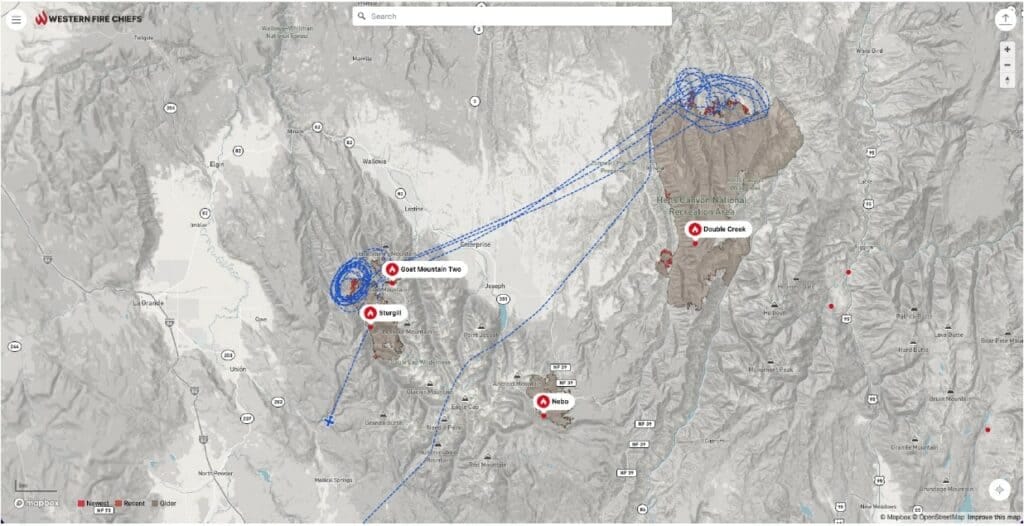
The WFCA Fire Map is the first of its kind to integrate real-time flight mapping of fire-fighting aircraft. Fire Suppression Aircraft are depicted on the WFCA Fire Map, with aircraft type, speed, and altitude.
When on Fire Map, clicking on an individual aircraft reveals its recent flight path indicating where current fire-fighting activity is taking place.
The WFCA Fire Map is also the first to depict Wildland Fire activity in 3D, where the viewer can rotate their vantage point around the fire map and view the fire from 360 degrees.
Another feature under Phase 2 will, specific to California, integrate fire-perimeter data provided by FIRIS and will be the first to do so.
FIRIS is a public-private partnership funded by the California Office of Emergency Services that provides real-time intelligence data on emerging incidents in California.
“FIRIS provides real-time situational awareness for firefighters on the ground, helping them make critical decisions. I believe that the same information helps the public, too. That is why we have partnered with the WFCA,” said Brian Fennessey, founder of FIRIS, California Fire Chiefs Fire Chief of the Year, and Orange
County Fire Authority Chief. FIRIS began in 2019 and uses the Overwatch Imaging platform, which includes an aerial infra-red (IR) platform that integrates cutting-edge technologies provided by Aevex Aviation. That data is fed to Intterra’s wildfire decision support software where WIFIRE retrieves the data for predictive analytics.
Fire Map was launched by the WFCA in July. The online tool pulls data from the US Forest Service via the National Interagency Fire Center IRWIN feed and 911 Dispatch data via PulsePoint to provide near real-time information about active and recent wildfires within the western United States and Alaska.
About the WFCA
The Western Fire Chiefs Association represents fire-related emergency service organizations throughout the west coast and Western Pacific Islands. The WFCA is dedicated to protecting people and the environment from the occurrence and outcomes of fires and other natural, technological, and human-behavior-caused emergencies.
Featured image from Western Fire Chiefs Association.